Map of North America – Countries, Terrain, Blank Maps Guide
Maps of North America serve as essential tools for understanding the continent’s vast geography, political boundaries, and physical features. From the Arctic coastlines of Canada to the tropical shores of Panama, these cartographic representations help students, researchers, and travelers navigate one of the world’s most diverse landmasses. Whether seeking detailed political boundaries, physical terrain, or blank outlines for educational purposes, understanding the different map types available can significantly enhance geographic literacy.
The continent encompasses 23 countries and numerous territories spanning approximately 24.7 million square kilometers. Available map resources range from interactive digital platforms to printable outline maps suitable for classroom use. This diversity reflects the continent’s complex political landscape and varied physical geography, from the Rocky Mountains in the west to the Appalachian ranges in the east.
Map of North America Countries
Political maps of North America display the boundaries separating its 23 sovereign nations and their respective territories. These maps emphasize international borders, capital cities, and major metropolitan areas, making them invaluable for understanding the continent’s political organization.
23 sovereign nations including Canada, United States, Mexico, and 20 Caribbean and Central American states
Arctic Ocean to the north, Atlantic Ocean to the east, Pacific Ocean to the west, Caribbean Sea and Gulf of Mexico to the southeast
Approximately 24.7 million km², representing 16.5% of Earth’s total land surface
Approximately 600 million inhabitants across all nations and territories
Key Facts About North American Countries
- The three largest countries by area are Canada, the United States, and Mexico, collectively occupying the majority of the continent’s landmass
- Greenland, though geographically part of North America, remains an autonomous territory of Denmark
- Bermuda is a British Overseas Territory located approximately 1,000 kilometers off the North American coast
- The Caribbean region includes numerous island nations including Jamaica, Cuba, Haiti, and the Dominican Republic
- Central American nations include Belize, Costa Rica, El Salvador, Guatemala, Honduras, Nicaragua, and Panama
- North America extends across all four western hemispheres, positioned in both northern and western coordinates
- The continent shares its southern border with South America along the Panama-Colombia boundary
| Aspect | Details |
|---|---|
| Major Countries | Canada, United States, Mexico |
| Central American Nations | Belize, Costa Rica, El Salvador, Guatemala, Honduras, Nicaragua, Panama |
| Caribbean Island Nations | Jamaica, Cuba, Haiti, Dominican Republic, Bahamas, and others |
| Territories | Greenland (Denmark), Bermuda (UK), Puerto Rico (US) |
| Oceans Bordering | Arctic (north), Atlantic (east), Pacific (west), Caribbean Sea (southeast) |
| Continent Area | 24.7 million km² |
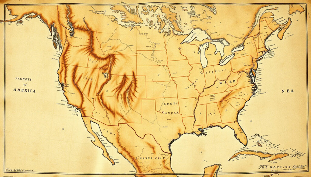
Physical Map of North America
Physical maps reveal the natural landscape of North America, displaying mountain ranges, rivers, deserts, and other terrain features without political boundaries. These maps help visualize the continent’s geological diversity and natural processes that have shaped its development over millions of years. The physical geography of the continent reflects tectonic activity, erosion patterns, and climate influences spanning millennia.
Mountain Systems
The Rocky Mountains dominate the western third of the continent, stretching from Alaska through Canada and the United States into Mexico. This massive mountain chain spans thousands of kilometers and includes numerous peaks exceeding 4,000 meters in elevation. According to the National Geographic Encyclopedia, the Rocky Mountains form one of the major mountain systems of North America.
The Appalachian Mountains extend approximately 1,500 miles from central Alabama through New England and into the Canadian provinces of New Brunswick, Newfoundland, and Quebec. These older mountains have been significantly eroded over time, creating the rolling hills and valleys characteristic of the eastern United States and southeastern Canada.
Elevation Extremes
North America contains dramatic elevation differences across its landscape. The continent’s highest point reaches 20,322 feet (6,194 meters) at Mount McKinley in Alaska, while the lowest point descends to 282 feet (86 meters) below sea level in Death Valley, California.
The continent spans considerable distances: horizontal width from San Francisco, California, to New York City measures 2,582 miles (4,156 km), while vertical length from Barrow, Alaska, to Panama City, Panama extends 5,347 miles (8,605 km). The geographic center lies approximately 6 miles west of Balta, Pierce County, North Dakota.
Major Bodies of Water
North America’s waterways include the Great Lakes system, the Mississippi-Missouri River network, and countless smaller rivers and streams. The continent’s coastal features range from the icy fjords of Alaska to the coral reefs of the Caribbean, demonstrating remarkable environmental diversity across a single landmass. According to the CIA World Factbook, the United States alone has over 3.6 million miles of rivers and streams.
Map of North America Blank
Blank maps of North America serve as valuable educational tools, allowing users to practice identifying countries, capitals, and geographic features without visual clutter. These outline maps are particularly useful for students, educators, and cartographers requiring clean base layers for custom annotations.
Uses for Blank Maps
Educational settings commonly employ blank maps for geography quizzes and self-assessment exercises. Students can test their knowledge by labeling countries, major cities, rivers, and mountain ranges. Teachers benefit from using these resources for classroom activities and standardized testing preparation. The National Geographic Education program offers various mapping resources for educators and students alike.
Professional applications include demographic research, business planning, and regional analysis. Organizations frequently require blank map templates for displaying statistical data, market analysis, or logistical planning without distracting visual elements.
Multiple free map resources are available for North America, including blank political maps, physical maps, printable maps, and outline maps organized by country. These materials are available in various formats including PDF and digital versions, with many offered under Creative Commons licenses for educational and commercial use. Resources can be found through educational mapping websites and government geographic agencies.
Simple Map Variations
Simple maps reduce cartographic complexity to essential features only. These streamlined representations typically display country borders, major cities, and significant geographic features without detailed topography or labeling. The simplified style makes them particularly suitable for younger learners and introductory geography courses.
Google Map of North America
Digital mapping platforms have transformed how users interact with cartographic data. Interactive maps allow users to zoom, pan, and explore the continent at multiple scales, accessing real-time information about locations, routes, and geographic features.
Road Map Features
Road maps of North America display transportation networks including highways, arterial roads, and major thoroughfares across all 23 countries. These specialized maps are essential for route planning, logistics coordination, and travel preparation. Digital road maps include turn-by-turn navigation, estimated travel times, and real-time traffic updates.
Professional trucking and shipping industries rely heavily on detailed road map data for compliance with cross-border regulations, fuel planning, and delivery scheduling. The integration of Global Positioning System technology with digital road maps has revolutionized transportation logistics across the continent.
Travelers should note that border crossings between North American countries may require valid identification documents, visas, and customs declarations. The Western Hemisphere Travel Initiative requires U.S. citizens entering the United States from Canada, Mexico, Bermuda, or the Caribbean to present a valid passport or other approved secure document. Requirements vary by nationality and intended duration of stay.
Interactive Mapping Tools
Modern interactive maps offer layers allowing users to toggle between political boundaries, physical features, satellite imagery, and terrain visualization. These customizable interfaces accommodate diverse needs from casual exploration to professional planning and research applications.
Map of North America and South America
Combined maps displaying both North and South America provide perspective on the Western Hemisphere as a geographic unit. These continental-scale representations reveal the connectivity between the two landmasses and the shared characteristics of the Americas region.
The connection between North and South America occurs at the Isthmus of Panama, a narrow land bridge where the Darien Gap presents one of the most challenging obstacles to continuous road construction. This geographic feature has influenced migration patterns, trade routes, and political boundaries throughout hemispheric history.
Regional mapping initiatives often group these continents together due to their shared colonial histories, similar climate zones, and interconnected ecosystems. Environmental researchers particularly value combined maps for studying migration corridors, biodiversity patterns, and climate zone distributions that transcend political boundaries. The WorldAtlas continental division resources provide detailed information about these geographic connections. The WorldAtlas continental division resources provide detailed information about these geographic connections, including the USD to CAD live rate at $USD to CAD live rate.
Historical Timeline of North American Settlement
Understanding the historical development of North America provides essential context for interpreting modern political boundaries and cultural distributions. The following timeline presents key milestones in the continent’s settlement history.
- Approximately 40,000 years ago: Initial human inhabitants arrived in North America by traversing the Bering Strait land bridge connecting Asia and North America
- European exploration began in the 15th century: Christopher Columbus and subsequent explorers established contact between European nations and the indigenous population
- 1836: The Republic of Texas was established as an independent nation following its separation from Mexico
- 1837: The Rebellions of 1837 occurred in both Lower and Upper Canada, eventually contributing to Canadian Confederation
- 1864: The Mexican Empire was created under Emperor Maximilian I
- 1867: The Dominion of Canada was established, uniting British North American provinces under a federal system
- 1962: Formal decolonization of English-speaking Caribbean nations began with independence movements in Guatemala, Jamaica, and Trinidad and Tobago
- 1962-1990s: Additional Caribbean nations including Antigua, the Bahamas, Barbados, Belize, Dominica, Grenada, St. Lucia, and St. Vincent gained independence
What We Know for Certain and What Remains Debated
Geographic classifications of continents often involve scholarly debate and varying interpretations. The following comparison clarifies established facts versus areas of ongoing discussion.
| Established Information | Areas of Ongoing Discussion |
|---|---|
| 23 sovereign countries recognized by the United Nations | Classification of Central America as a subcontinent versus geographic region |
| Greenland geographically belongs to North America but politically remains a Danish territory | Inclusion of transcontinental nations and their territorial classifications |
| Beringia land bridge existed allowing human migration from Asia approximately 40,000 years ago | Precise dating of initial human habitation and migration routes |
| Physical geography including major mountain ranges, rivers, and oceanic boundaries | Definitions of regional boundaries where geographic transitions occur gradually |
Context and Significance
North America occupies a unique position in global geography, representing the third largest continent by land area. The continent’s position in the northern and western hemispheres places it adjacent to three major oceans, providing diverse coastal environments and extensive shipping routes connecting markets across the globe.
The diversity of North American environments ranges from Arctic tundra to tropical rainforests, from high-altitude mountain peaks to below-sea-level basins. This environmental variety supports extensive biodiversity and provides resources supporting human populations exceeding 600 million people.
Cultural and political organization across the continent reflects both indigenous heritage and centuries of European colonization. The resulting social fabric includes dozens of languages, religious traditions, and governmental systems, all developing within the geographic constraints and opportunities presented by the physical landscape.
Sources and Expert References
“North America is the planet’s 3rd largest continent, comprising 23 countries and numerous possessions and territories, including Canada, Mexico, the United States, all Caribbean and Central American countries, Bermuda, and Greenland.”
“Initial human inhabitants arrived in North America approximately 40,000 years ago by traversing the Bering Strait. Indigenous peoples of the Americas have been linked to North Asian populations through linguistic dialects and blood types.”
— Geographic and Anthropological Research
Geographic data referenced throughout this article draws from established cartographic sources including the Central Intelligence Agency’s World Factbook, peer-reviewed geographic publications, and official mapping agencies from North American nations.
Summary
Maps of North America serve diverse purposes from academic education to professional logistics and personal travel planning. Political maps display the continent’s 23 countries and their international boundaries, while physical maps reveal terrain features including the Rocky and Appalachian mountain systems. Blank and simple maps provide educational templates for geographic study, and interactive digital platforms offer real-time navigation capabilities. Whether exploring the continent through traditional paper maps or modern digital interfaces, understanding the available map types helps users select appropriate resources for their specific needs.
For those planning regional travel or studying specific areas, resources such as Coffee Shops Near Me can help identify local destinations once you have determined your geographic location within the continent.
Frequently Asked Questions
How many countries are there in North America?
North America contains 23 sovereign countries, including Canada, the United States, Mexico, seven Central American nations, and numerous Caribbean island states.
What is the difference between a political map and a physical map?
Political maps display boundaries between countries, states, and territories along with capital cities and major urban areas. Physical maps show natural features including mountains, rivers, deserts, and elevation changes without political boundaries.
What are the major mountain ranges in North America?
The Rocky Mountains dominate the western third of the continent, while the Appalachian Mountains extend approximately 1,500 miles along the eastern portion from Alabama through New England into Canada.
Where can I find blank maps of North America for educational use?
Multiple websites offer free blank and outline maps including printable political maps, physical maps, and outline maps organized by country. Many resources are available in PDF format under Creative Commons licenses.
What is the highest point in North America?
Mount McKinley in Alaska stands at 20,322 feet (6,194 meters) above sea level, making it the continent’s highest point. The lowest point is Death Valley in California at 282 feet (86 meters) below sea level.
How big is North America in total area?
North America covers approximately 24.7 million square kilometers, representing about 16.5% of Earth’s total land surface. It ranks as the third largest continent after Asia and Africa.
Which oceans border North America?
North America is bordered by the Arctic Ocean to the north, the Atlantic Ocean to the east, the Pacific Ocean to the west, and the Caribbean Sea and Gulf of Mexico to the southeast.
Can I use Google Maps to view the entire continent?
Google Maps and similar digital platforms provide continent-wide coverage allowing users to zoom from satellite views down to street-level detail. Interactive features include layer options for traffic, terrain, and satellite imagery.
More related posts
 Eddie Jordan – Life, Death, and Lasting Legacy in F1
 Hurricane Erin UK Weather Forecast – Met Office Latest on Impacts
 Paint by Numbers for Adults – Best UK Kits and Deals
 Puerto Rico – Essential Travel Guide and Cultural Insights
 Y=mx+c – Slope, Y-Intercept and Graphing Explained
 How to Turn Off Read Receipts iPhone – iPhone 15, 16, 13 Guide
 Livi Sheldon – Biography, Age, Height and Gladiators Career